Sue and Martin in Mallorca 2019

Sue and Martin in Mallorca 2019
On the Archduke's Path in Mallorca
Showing posts with label Dales Way. Show all posts

Tuesday, 17 September 2024

Monday 16 September 2024 - A Sedbergh Circuit


I was supposed to meet Markus on the summit of Ingleborough yesterday lunchtime. It would not have been pleasant. Driving rain was forecast all day, and that turned out to be correct. A last minute adjustment to plans was necessary, though without Wifi or a phone signal, Markus was completely in the dark. Instead of going to Chapel-le-Dale on Sunday, I went to Sedbergh on Monday, in the knowledge that Markus was booked into a hotel there. From there I walked along the Dales High Way (DHW) route to beyond Dent, and I met Markus coming the other way after having climbed Whernside, pretty much exactly where I expected him to appear.

I faffed on riverside paths and returned to the car to take it to a better place in a layby beside the River Rawthey, on the DHW route. Autumn has yet to trouble the greenery in the Yorkshire Dales.


Sedbergh and the Howgills from the DHW path

Panorama (click on it to enlarge) towards the Howgills from Long Moor

Elevenses on Long Moor

View towards Middleton Fell on the descent from Long Moor

Hover Fly on Rampion

On the descent to Dent, a very narrow lane winds up to this vacant cottage.


The road to Dent is encountered at Barth Bridge, from where the DHW and Dales Way paths lead on to Dent beside the River Dee. I'd met not a single person before reaching the outskirts of Dent.


After passing through Dent, and checking that Markus wasn't there, I continued to Church Bridge, for a long lunch on a bench in the playing fields with this view:


Church Bridge

Just a bit further on, I met Markus at Double Croft. I turned around and we enjoyed good views of the river, and refreshments at the cafe in Dent Village Heritage Centre..


Knapweed

Oxeye Daisy

Markus, the camera shy Austrian, insisted that he take my picture outside my Bank.


We then continued on along the Dales Way path until we reached a tempting new footbridge at Ellers.


Appearances can be deceptive, it's already starting to fall apart!

Other walkers continued along the Dales Way, but we took a nice alternative route on sometimes vague paths via Mire House and Burton Hill to rejoin the Dales Way route at an attractive bridleway at Gap.


Markus strides along the scenic bridleway that leads to the hamlet of Millthrop


After a gentle rise, the Howgills and Sedbergh came into view.


One of the gardens in Millthrop was overflowing with plants of all colours. It must win awards.


The River Rawthey was crossed for a final time, before we made our way past the sports grounds of Sedbergh School and through the small town to the Dalesman Inn.


Here's my route - an excellent day's walk of about 23 km, with just 350 metres ascent. It took me around 7 hours, at least 2 hours of which was at rest.


We were both glad that I'd delayed my visit for a day, and we enjoyed beers and a good meal at the pub before I wended my way home.

Amongst what I observed today:
Thistles, Dandelions, Knapweed, Harebells, Oxeye Daisy, lots of Tormentil on Long Moor, Yarrow, Pineappleweed, Meadow Cranesbill.
Not a lot of birds apart from the usual common ones, but I did spot a Wheatear - shouldn't it have migrated by now? ["Not this week, it's still summer here..."]

Friday, 23 October 2015

Wednesday 21 October 2015 – A Stroll around Windermere town

2105sheep2

Wednesday brought a series of pleasurable episodes.

First, a visit to Jose and Hugh at Alpenstock in Stockport. “Fancy a coffee” were their first words as I entered the shop. No wonder that they have again been shortlisted in The Great Outdoors magazine’s retailer of the year category for their 2015 awards.

Anyway, after (not unexpectedly) coming away with rather more than the intended spare poles for our Hilleberg Nallo tent, I moved on to the next pleasurable activity.

German Martin’s EasyJet flight from Berlin was on time. I met Martin in the Pyrenees on my GR11 walk. He is one of a number of GR11 friends who will be congregating in Leyburn next weekend. Here he is in the Pyrenees.

2120martin

Martin was on his way to the Lake District to attempt a circular walking tour devised by Jim Reid. There’s a Cicerone guide, and the route is shown below in blue, with some alternatives in green.

2150route

Conrad (aka Sir Hugh), who often comments on these pages, lives en route to Martin’s Windermere destination, so we called in for another most pleasurable hour, during which I gave Martin some maps and tried to brief him, with Conrad’s help, on the route. It was great to meet you again, Conrad, and thank you for the coffee and biscuits.

After that, a short drive to Windermere saw Martin grabbing some last minute provisions and heading off into the hills. Over a day later, his phone was discovered at Conrad’s house. Oops!

I couldn’t visit the Lake District without some sort of a walk, especially as the mizzle appeared to have stopped for a couple of hours. So off I set, aiming for a path that skirts the eastern side of the town and eventually meets the Dales Way path on which an easy descent to Bowness is made.

Don’t make my mistake of heading down Thwaites Lane if you do this walk; continue on the footpath beside the A591 to a footpath on your right.

Whichever way you go, you’ll cross Mill Beck, then gain views across bumpy farmland to School Knott.

2102schoolknott

Scout Beck is then crossed, after which I enjoyed a few minutes in the company of a chap who was out for a walk with Meg, a working sheepdog whose frustration at being ‘on holiday’ was starting to show. She wanted to work.

2103MillBeck

If the characters below are representative of Meg’s ‘clientele’, then that dog has an easy life!

2104sheep1

Beyond High Cleabarrow the Dales Way route is reached. I turned right here, and headed down to Matson Ground, where mallards and moorhens paddled around in the midst of a family of swans whose crop of six or seven goslings were still appreciating the support of their parents.

2108matsonground3

As the path descends inexorably towards Bowness there are plenty of places for weary Dales Way walkers to rest their feet before finishing the 81 mile trek from Ilkley.

2111seat

A few hundred metres dogleg to the left takes you to a good viewpoint over the lower reaches of the lake.

2113viewpoint

Soon after that, surrounded by a deep dark brown carpet of autumn leaves, is a final resting point before descending to the fleshpots.
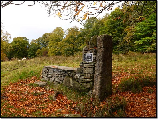
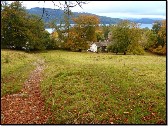
2116dalesway22117daleswayend

Bowness was fairly quiet on this late afternoon in October, and with dusk approaching the bowling green was deserted. The town was however much busier than I’d found its Pyrenean counterparts to be back in July.
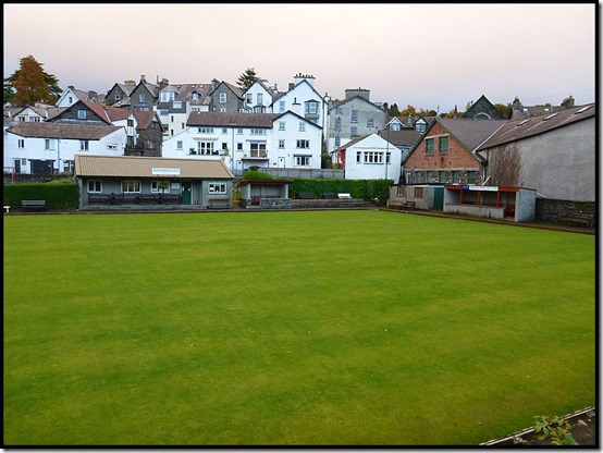
2118bowls

A stroll along traffic free Longlands Road saw me back in Windermere after 9.5km and about two hours. It was 6pm. There was a chippy. And an unexpected chat with the fryer about long distance walking routes.

2199route

An easy drive home concluded a lovely day out.

Tuesday, 9 June 2009

June 1 to 6, 2009 - A Walk based on The Dales Way

0901titleI'm not doing a detailed index for this trip.  To view all the postings, scroll down the page from here, clicking on 'Older Posts' at the bottom right of each page, until you get to 'Windermere to Manchester - A Plan' - an entry posted on 30 May.  Work upwards from there, clicking on 'Newer Posts' at the bottom left of the page when you reach the top of the page (if you see what I mean).

I've uploaded some images from the trip here.  Click on the slideshow button to view the show, the parameters for which are easy adjusted by placing the cursor near the bottom of the screen.
I hope you enjoy them.

Here are the statistics for the trip:
Day 1 - Windermere to Potter Tarn - 19 km, 650 metres ascent - 6.2 hours including 0.8 hours breaks
Day 2 - Potter Tarn to Dent - 44 km, 1240 metres ascent - 12.6 hours including 2.3 hours breaks
Day 3 - Dent to Kettlewell - 46 km, 1300 metres ascent - 11.9 hours including 2.3 hours breaks
Day 4 - Kettlewell to White Wells - 40 km, 950 metres ascent - 11.9 hours including 2.4 hours breaks
Day 5 - White Wells to Jerusalem Farm - 36 km, 940 metres ascent - 11.5 hours including 2.0 hours breaks
Day 6 - Jerusalem Farm to Ripponden  - 10 km, 350 metres ascent - 2.6 hours including no breaks
TOTAL: 195 km (122 miles) with 5430 metres ascent

My detailed route plan, which I stuck to up to Ripponden with only very minor deviations, is here.

Gayle's excellent report on the Denholme to Ripponden section is here.

My kit list is similar to that for the TGO Challenge (here), plus the Phreerunner tent and a few other items - I was probably carrying an acceptable average of about 15 kilos.  I may comment on specific items in a separate posting.

Saturday, 6 June 2009

Saturday 6 June 2009 - Fair Weather Walkers

This final 'mobile' image is of the disused railway viaduct at Hewenden - one of many fine man-made structures in the area. It was taken yesterday shortly before I met Mick and Gayle and the weather changed.

The weather certainly did change, with 'winter gear' being deployed. We decided not to seek refuge at Mick's mum's house, as Mick wanted to test his new mattress - a Thermarest Neo-Air thingy. (He liked it!)

Jerusalem Farm campsite has good drainage. It needed it last night.

This morning we woke to the sound of a gargling magpie, got an early start as planned, and enjoyed a stroll by the river to Luddenden Foot. A pleasant walk by the canal (in the wrong direction for 'Manchester - 30 miles') was followed by a steep ascent to Sowerby. From there we dropped back to the Ryburn valley, down a steep cobbled path. Having already seen Mick test the braking power of his rucksack on some earlier cobbles, we were understandably very careful here - using the deep wet grass either side of the cobbles as much as we could.

"Nice weather for ducks" chirped the postman, as he delivered to posh houses on the east bank of the river beyond Triangle. Here the pleasant woodland and a disused railway led us eventually to the metropolis of Ripponden.

We'd been walking in the rain for nearly three hours. We were perhaps a little damp generally, but our feet (subject to Sealskinz/goretex socks) could justifiably be described as 'soggy'. Mine were soaking wet.

The café in Ripponden served excellent tea and bacon/egg butties. We lingered there.

Then Sue arrived. She showed me the choice of trainers and boots she had brought for me to change in to due to a sore ankle. The trainers would be a vast improvement over my Crocs, which aren't the premium footwear for slippery cobbles. She had thoughtfully packed some waterproof socks as well.

The rain thickened.

"Rain all weekend, is the forecast" said Sue.

"Let's go home!"

"What! How could we!"

The rain lashed down as we chauffered M + G on the short drive to Mick's mum's house, and it continued unabated as we sloshed back home to Manchester.

A hot bath, some nice meals, and a lazy weekend sorting the photos from a sunny 120+ mile walk. Better than a 40+ mile walk in the rain with a sore ankle from Ripponden to Timperley, via Crowden?

I thought so. That section can wait until its scenery can be enjoyed in the sun - today some of it was in Cold Cloud.

Readers are of course welcome to their own opinion, but hopefully by Monday I'll have uploaded some images from the 'Windermere to Ripponden' route to an on-line album for all to peruse.
Now done.

I'll put a link, and some summary information for this most enjoyable trip, on the next posting.

Have a nice weekend, everyone.

Friday, 5 June 2009

Friday 5 June 2009 - M & G Come For A Walk

What happens? Mick and Gayle arrive, and it rains - it had started to 'spot' when the previous posting was sent.

We had enjoyed some excellent fish 'n chips at our rendezvous point in Denholme, where the only pub opens at 2pm, and had 'provisioned' at the Co-op, but by the time we passed Thornton Moor Reservoir it had cooled considerably and the rain became persistent.

Good navigation and chatting don't always go together, we noted, as we wandered vaguely along the thin blue line I'd plotted to Jerusalem Camp Site near Booth.

The tea shop at Ogden Water provided a welcome break and an entertaining dialogue between Mick and the deaf attendant.
Mick: "Three teas, please?"
Lady: "We sell polos."
Mick: "Three teas, please?"
Lady: "We sell chocolate."
Mick: "Three teas, please?"
Lady: "Would you like to buy an ice cream?"
Mick: "Aha" - realises he is standing next to the tea machine.

After that the rain eased as we strolled onwards to the campsite and got our tents up in lighter rain than the current deluge.

It's a small site, but we are showered and I've washed some clothes - who knows when they will dry! All is well and we are cosy and cooking in our respective tents.

There's no photo with this, as no signal at camp and only a weak one up this hill.

So that's it for today?

Well - before M & G joined me......

I woke to two deep long belches. An insomniac sheep?

The tent shook.

"Yer not allowed to camp on moorland."

'Moron' I thought.

"Don't worry, I'll be away early."

"Mek shore y'are" came the response.

A distant clock chimed midnight.

'Moron' I thought.

I slept well, and soon after the crack of dawn I was being led by a strolling curlew up to Ilkley Crags on a fine but cool morning.

Mist lay in the valleys and smoke rose lazily from a distant power station. The 12 apostles (an ancient stone circle) were soon passed, after which an easy amble past curlew and plovers took me beyond the cotton grass zone to Otley Road, where frantic commuters tore past 'Dick Hudsons' pub as they rushed to work.

My pace was slower. I was soon back in the 'bluebell zone', with narrow paths weaving between the posh estates of the horsey and famous of Yorkshire.

I passed 'Woodpecker Man', his cameras focused on a hole in a tree a few metres away, in lovely woodland where red campion fought for space with greater stitchwort and marsh marigolds lined the banks of a brook.

It was a lovely, varied route. I was proud of my hastily devised blue line on the map. I made lots of notes today on a number of points of interest, but they'll just have to wait for an editing session, as it's going dark here and sleep is needed.

Goodnight.

Decided no further edit needed - just a link (here) to Mick and Gayle's report.

Mick + Gayle Arrive

It starts to rain!

Urban Arteries

I'm now sitting on a grassy bank under a main road at (wrong - this was a new road overhead, waypoint 53 still being some way off!) waypoint number 53, imaginatively named 'A650 road'. The roads, rivers, canals and railways hereabouts vie for space with each other, and with ancient ways like the walled one shown, that I'm following through lovely woods.

Back on the Dales Way

After pleasant South Pennine moorland from Ilkley, with curlews and plovers in plenty, the cotton grass has been replaced by the buttercup fields through which this 'Bradford to Ilkley Link' section of the Dales Way passes.